

Cuba is not just an island.
The Republic of Cuba consists of two large islands (Cuba and the Isle of Pines or Isle of Youth) and over 4000 islands, islets and keys.
Isla de Pinos is the smallest of the Greater Antilles.
Due to its size (2,199 km 2) and its geographical location, it can be considered the smallest of the Greater Antilles.
The extreme points of the geography of the Island of Cuba.
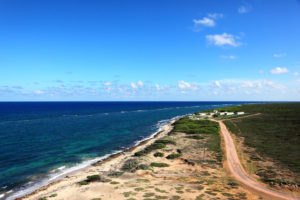
To the north the Punta del Francés in the Peninsula of Hicacos, to the south the Punta del Inglés in Cabo cruz, to the east the Punta de Maisí and to the west the Cape of San Antonio.
The greater depth of the Caribbean Sea is to the south of Cuba.
This is the Bartlet Trench between Cuba and Jamaica.
Rio Cauto.
The largest river in the Antilles is not the Cauto.
With its 270 km of length is the greater fluvial route of the Antilles with more than 100 navigable kilometers but it is not the greater river. You are overcome by 3 Dominican or Haitian rivers.
The Turquino is the highest height of Cuba but it is far from the highest peaks of the Antilles.
In fact, it measures 1974 m, very far from the Duarte peak of Republica Dominicana with 3087 ms or of the greater heights of Haiti and Jamaica.
The island of Cuba occupies half the Antilles.
Cuba has the same surface as the rest of the Antilles.
Cuba is the most populated country in the Antilles.
Of the 10 people who live in these islands, 3 do it in Cuba, but more than 4 live in the island of Hispaniola (Haiti and Santo Domingo).
Cuba has 15 cities with more than 100,000 inhabitants.
In fact, they include Havana with more than 2 million, Santiago de Cuba with more than 500,000 and Camagüey and Holguin with more than 300,000.
Manzanillo.
Of the great Cuban cities the one of smaller population growth in the last 20 years is Manzanillo.
Save The City of Havana, with more than 2300000 inhabitants and a large floating population, is Manzanillo the one with the lowest population growth, going from place 11 between the cities of Cuba to number 13.
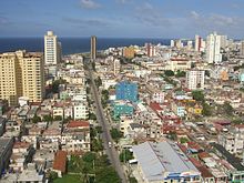
Havana is the most populated city in the Caribbean.
However it is not the longest that turns out to be Santo Domingo
The highest point of the geography of Cuba is not natural but created by man.
This is the bust of José Martí placed on the top of Turquino in 1953, the work of the sculptor Gilma Madera and adds more than a meter to that mountain.
Baracoa is the first city founded in Cuba and yet it was isolated by road for 450 years.
Founded in 1510 it did not have communication by land until the Viaduct of the Lamp was created 450 years later.
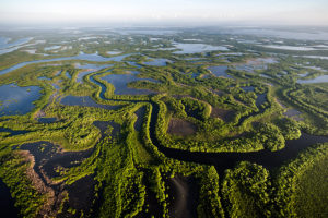
The Cienaga de Zapata is the largest wetland in the Caribbean.
It is not only the largest, but the best preserved according to international organizations.
![]()
COSAS QUE USTED DEBE SABER SOBRE CUBA. .
Cuba no es sólo una isla.
La República de Cuba está formada por dos islas grandes (Cuba y la Isla de Pinos o Isla de la Juventud) y por más de 4000 islas, isletas y cayos.
Isla de Pinos es la menor de las Antillas Mayores.
Por sus dimensiones (2,199 km 2) y por su situación geográfica puede considerarse la menor de las Antillas Mayores.
Los puntos extremos de la geografía de la Isla de Cuba.
Al norte la Punta del Francés en la Península de Hicacos, al sur la Punta del Inglés en Cabo cruz, al este la Punta de Maisí y al oeste el Cabo de San Antonio.
Punta de Maisi.
La mayor profundidad del Mar Caribe está al sur de Cuba.
Se trata de la Fosa de Bartlet entre Cuba y Jamaica.
El mayor río de las Antillas no es el Cauto.
Con sus 270 km de longitud es la mayor vía fluvial de las Antillas con más de 100 km navegables pero no es el mayor río. Le superan 3 rios dominicanos o haitianos.
El Turquino es la mayor altura de Cuba pero dista mucho de las mayores cimas de las Antillas.
En efecto, mide 1974 m, muy alejado del pico Duarte de Republica Dominicana con 3087 m o de las mayores alturas de Haití y Jamaica.
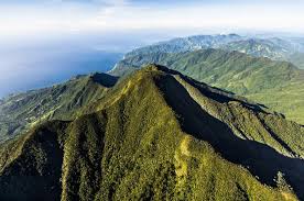
Pico Turquino.
La isla de Cuba ocupa la mitad de las antillas.
Efectivamente Cuba tiene la misma superficie que el resto de las Antillas sumadas.
Cuba es el país más poblado de las Antillas.
De cada 10 personas que viven en estas islas 3 lo hacen en Cuba, sin embargo mas de 4 viven en la isla de la Española (Haití y Santo Domingo).
Cuba tiene 15 ciudades de más de 100000 habitantes.
Efectivamente, entre ellas se incluyen La Habana con mas de 2 millones, Santiago de Cuba con más de 500000 y Camagüey y Holguín con más de 300000.
De las grandes ciudades cubanas la de menor crecimiento poblacional en los últimos 20 años es Manzanillo.
Salvo La Ciudad de La Habana, con más de 2300000 habitantes y un gran población flotante, es Manzanillo la de menor crecimiento poblacional pasando del lugar 11 entre las ciudades de Cuba al número 13.
La Habana.
La Habana es la ciudad más poblada del Caribe.
Sin embargo no es la más larga que resulta ser Santo Domingo
El punto más alto de la geografía de Cuba no es natural sino creado por el hombre.
Se trata del busto de José Martí colocado en la cima del Turquino en 1953, obra de la escultora Gilma Madera y añade más de un metro a esa montaña.
Baracoa es la primera ciudad fundada en Cuba y sin embargo estuvo aislada por carretera durante 450 años.
Fundada en 1510 no tuvo comunicación por tierra hasta que se creó el viaducto de la Farola 450 años más tarde.
La Cienaga de Zapata es el mayor humedal del Caribe.
No solo es el mayor, sino el mejor conservado según los organismos internacionales.
Agencies/GeografiaMiPais/Internet Photos/Arnoldo Varona/TheCubanHistory.com
THE CUBAN HISTORY, HOLLYWOOD.

Santiago de Cuba.