 CUBA DESCONOCIDA: GUARACABULLA, PLACETAS, LAS VILLAS.
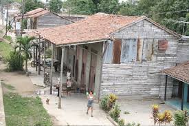
Guaracabulla es una localidad que se encuentra ubicada en el municipio Placetas, Villa Clara, contando con 581 viviendas y 1662 habitantes según los últimos estimados. Demográficamente está catalogado como un poblado rural.
Sobre el nombre de la localidad rural existen varias versiones que provoca el interés de lingüistas, porque se escribe indistintamente con y o doble ele, sin constituir falta ortográfica.
Guaracabuya, notorio por ser el primer centro geográfico conocido de Cuba. La condición de primer centro geográfico de Cuba se remonta al año 1814 con la fundación de la aldea de San Atanasio de Guaracabuya, con pobladores de San Juan de los Remedios, que ante los ataques de corsarios y piratas decidieron trasladarse más al centro de la Isla, entre otras historias.
La localidad se encuentra en los 79,73861111 grados de Longitud Oeste y en los 22,25888889 grados de Latitud Norte, posición geográfica que la ubica al este sureste de Santa Clara, la cabecera provincial, y a una distancia de 10 kilómetros cartesianos de Placetas, la cabecera municipal. Guaracabulla es un pueblo pobre, donde no hay mucho que hacer. La gran contradicción es que viven sobre una mina de oro.
Hacia principios de los años 1800 el partido de Guaracabulla se declaraba situada en el centro de Cuba ocupaba cinco mil doscientas noventa y cinco caballerías cuadradas y limitaba al norte con el de San Francisco de Camajuaní, al sur con la jurisdicción de Santi Spíritus, al este con El partido de Gueiba y al oeste con la jurisdicción de Santa Clara.

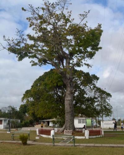
Una ceiba marca el sitio de un posible o errado centro de la geografía de la ínsula, pero lo más importante es que la señal realmente indica mucho de la identidad de los pobladores de la localidad .
La localidad está enclavada en un sitio fresco y alto, con agua potable. Toda la zona vecina forma placeres carentes de vegetación que se alternan con espacios de abundante y rica flora. Las condiciones geográficas de la zona hacen que las temperaturas promedios diarias en la localidad oscilen entre una máxima media de 29,97 grados centígrados y una mínima media de 21,12 grados centígrados. Los vientos muestran durante todo el año una tendencia promedio a soplar desde el este de la localidad con una rapidez promedio de 8,3 kilómetros por hora.
Las lluvias en la localidad alcanzan un total acumulado anual de 1.165,5 milímetros con 121,1 días de lluvias y una humedad relativa en la atmósfera que alcanza el 81,34 % como promedio.
Acerca del patronímico de la comunidad existen versiones como la voz de “guarda la cabuya”, cuerda con la que los colonizadores españoles midieron a Cuba hasta llegar a su mitad, de acuerdo con el imaginario popular. También se habla de que en los orígenes del poblado abundaban las guacamayas, arbusto de doce pies de altura con flores de cinco pétalos amarillos y por el centro color de fuego.
Según estimados, la localidad cuenta con una población superior a las mil 600 personas.
Estudios posteriores tratan de ubicar, con exactitud el centro de la Isla, pero Guracabuya tiene el encanto de lo primero y la magia de la sabia popular.
 UNKNOWN CUBA: GUARACABULLA, PLACETAS, THE VILLAS.
Guaracabulla is a locality that is located in the municipality Placetas, Villa Clara, with 581 homes and 1662 inhabitants according to the latest estimates. Demographically, it is classified as a rural town.
On the name of the rural town, there are several versions that provoke the interest of linguists, because it is written indistinctly with y and or double ele, without constituting a lack of spelling.
Guaracabuya, notorious for being the first known geographic center of Cuba. The condition of the first geographic center of Cuba goes back to the year 1814 with the foundation of the village of San Atanasio de Guaracabuya, with settlers of San Juan de Los Remedios, that before the attacks of corsairs and pirates decided to move more to the center of the Island, among other stories.
The locality is in the 79,73861111 degrees of West Longitude and in the 22,25888889 degrees of North Latitude, a geographic position that locates it to the east southeast of Santa Clara, the provincial head, and to a distance of 10 kilometers Cartesian of Placetas, the municipal seat.

A ceiba marks the site of a possible or mistaken center of the geography of the island, but the most important thing is that the signal really indicates much of the identity of the local people.
Towards the beginning of the 1800s, the Guaracabulla party declared itself to be located in the center of Cuba, occupying five thousand two hundred and ninety-five square cavalries and bounded on the north by San Francisco de Camajuaní, on the south by the jurisdiction of Santi Spíritus, on the east with the party of Gueiba and to the west with the jurisdiction of Santa Clara.
The town is located in a cool and high place, with drinking water. The whole neighboring area forms pleasures devoid of vegetation that alternate with spaces of abundant and rich flora. The geographical conditions of the area mean that the average daily temperatures in the locality oscillate between an average maximum of 29.97 degrees Celsius and a minimum average of 21.12 degrees Celsius. The winds show throughout the year an average tendency to blow from the east of the town with an average speed of 8.3 kilometers per hour.
The rains in the locality reach a cumulative annual total of 1,165.5 millimeters with 121.1 rainy days and relative humidity in the atmosphere that reaches 81.34% on average.
About the patronymic of the community, there are versions such as the voice of “Guarda la cabuya”, a string with which the Spanish colonizers measured Cuba up to its half, according to the popular imagination. It is also said that the origins of the town abounded the macaws, a bush of twelve feet high with flowers of five yellow petals and the center color of fire.
According to estimates, the town has a population of more than 1,600 people.
Later studies try to locate, with exactitude the center of the Island, but Guracabuya has the charm of the first thing and the magic of the popular wisdom.
Agencies/ Wiki/ ACN/ Luz M. Martinez/ Martha Ríos/ Extractos/ Excerpts/ Internet Photos/ Arnoldo Varona/ www.TheCubanHistory.com
THE CUBAN HISTORY, HOLLYWOOD.


 < UNKNOWN CUBA: GUARACABULLA, Placetas, Las Villas Province.


