EL MALECÓN HABANERO, UN EXTENDIDO PROYECTO DE LA CONSTRUCCION NACIONAL.
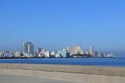
El Malecón de la Habana es una amplia explanada, calzada y dique que se extiende por 8 km (5 millas) a lo largo de la costa en La Habana, Cuba, desde la boca del puerto de La Habana en La Habana Vieja, a lo largo del norte lado del barrio Centro Habana y el barrio del Vedado, que termina en la desembocadura del río Almendares.
El Malecón comenzó a construirse el 6 de mayo de 1901, en tiempos de la intervención militar norteamericana. Al cesar esta e instaurarse la República, el 20 de mayo de 1902, la obra llegaba a la esquina con la calle Crespo.
Esto es, había recorrido un tramo de 500 metros. A causa de la irregularidad de los arrecifes, los cimientos del muro presentaron muchas dificultades en ese primer tramo, precisa Juan de las Cuevas, historiador de la Construcción.
El proyecto norteamericano contemplaba la presencia de árboles y farolas en el muro, pero la idea fue desechada al llegar la temporada invernal y entrar los primeros «nortes».
La obra continuó su curso. En 1909 llegaba a Belascoaín, donde abrió sus puertas el café Vista Alegre.
Siete años después se extendía hasta el torreón de San Lázaro, para lo que se impuso rellenar la caleta del mismo nombre —frente al actual hospital Ameijeiras— que tenía 93 metros de ancho en la boca y 5,5 metros de profundidad.
El huracán del 9 de septiembre de 1919 —el llamado ciclón del Balvanera— afectó grandemente ese tramo; le arrancó trozos inmensos de hormigón y los adentró en la ciudad.
A partir de 1921 la obra avanzó hasta la Avenida 23, pero habría que esperar un par de años para que se reconstruyera el tramo frente a la caleta.
La obra, al pasar frente al promontorio de la batería de Santa Clara —Hotel Nacional— hasta la calle O, exigía separar el muro unos 30 metros del litoral y rellenar un área de más de 100 000 metros cuadrados, con vistas a la construcción del monumento al acorazado Maine.
Los estudios para prolongar el Malecón hasta la desembocadura del río Almendares datan de 1914. Extenderlo hacia el sur, desde el castillo de La Punta hasta la Capitanía del Puerto, fue una idea que surgió en 1921.
Esta avenida se uniría con el tramo del Malecón ya construido y daría un fácil acceso al puerto desde el Vedado. El proyecto comprendía ganarle 111 000 metros cuadrados al mar, de los cuales gran parte se destinarían a parques y soluciones viales.
Las obras del muro, sin el relleno, las obtuvo en subasta la firma de contratistas de Arellano y Mendoza a un costo de 2 101 000 pesos y se calcula que el relleno costó otro millón de pesos adicionales.
Para realizar la obra se colocaron a lo largo de la línea donde se construiría el muro dos hileras de tablestacas de hormigón armado; también se hincaron pilotes en profusión cada 2,50 metros. Sobre las tablestacas y los pilotes se corrieron arquitrabes de hormigón armado.
El muro se realizó a base de unos grandes bloques huecos de hormigón armado, prefabricados en una planta que hicieron al efecto los contratistas en la Ensenada de Guanabacoa.
Estos bloques, aunque de dimensiones variables, tenían como promedio cinco por cuatro metros de área y dos metros de altura y descansaban sobre un fondo preparado con una base de hormigón y después se rellenaban también con hormigón, dejando fuera las cabillas que se empataban con todo el muro fundido a lo largo de la línea de los bloques.
Precisa Juan de las Cuevas que en este tramo se gastaron 17 000 toneladas de cemento Portland, 22 000 metros cúbicos de arena, 45 000 metros cúbicos de piedra picada, 35 000 metros cúbicos de rajón, 4 200 toneladas de barras de acero, 295 toneladas de vigas de acero y un millón de pies de madera.
La obra se comenzó en marzo de 1926 y se terminó en 1929. Para hacerla posible hubo, en un comienzo, que demoler la glorieta de Prado y Malecón, frente a La Punta, donde la Banda Municipal de Conciertos amenizaba las retretas.
Obstaculizaba el tráfico hacia el puerto. Esa glorieta, decía el arquitecto Bay Sevilla, fue la primera obra de hormigón armado, esto es con cabillas, que se realizó en Cuba.
El general Gerardo Machado y Carlos Miguel de Céspedes, su inquieto ministro de Obras Públicas, extendieron el Malecón hasta la calle G.
Precisamente en G y Malecón quería Céspedes, en un acto de guataquería insuperable, erigir un monumento a Machado, pero el dictador fue derrocado antes y él, su ministro y otros funcionarios de su régimen tuvieron que salir de Cuba.
Otro dictador, el general Fulgencio Batista, alrededor de 1955 adelantó el Malecón hasta la calle Paseo, pero allí se interpuso el Palacio de Convenciones y Deportes, situado donde hoy se encuentra la Fuente de la Juventud, frente al hotel Havana Riviera.
Desde 1950 se hablaba de prolongar el Malecón hasta el nivel de la calle 12, en el Vedado, para, a través de un puente colgante gigante, enlazar con la Avenida Primera de Miramar, cerca de donde después se edificó el hotel Rosita de Hornedo, hoy hotel Sierra Maestra.
En esa época, al oeste del Palacio de Convenciones y Deportes no se había trazado el Malecón ni existían en el área viviendas u otras edificaciones.
Pero la construcción del túnel de Calzada, bajo el río Almendares, en 1958, determinó que el Malecón enlazara con esa vía subterránea que terminaría uniéndolo, ya en 1959, con la Quinta Avenida.
EL MALECON HABANERO, EXTENDED NATIONAL CONSTRUCTION PROJECT.
The Malecón de la Habana is a wide esplanade, causeway, and levee that stretches for 8 km (5 miles) along the coast in Havana, Cuba, from the mouth of the port of Havana in Old Havana, to them along the north side of the Centro Habana neighborhood and the Vedado neighborhood, which ends at the mouth of the Almendares River.
The Malecon began construction on May 6, 1901, at the time of the American military intervention. When this ceased and the Republic was established, on May 20, 1902, the work reached the corner with Crespo Street.
That is, he had traveled a section of 500 meters. Due to the irregularity of the reefs, the foundations of the wall presented many difficulties in that first section, says Juan de las Cuevas, construction historian.
The North American project contemplated the presence of trees and lampposts on the wall, but the idea was rejected when the winter season arrived and the first “norths” entered.
The work continued its course. In 1909 it arrived in Belascoaín, where the Vista Alegre café opened its doors.
Seven years later it extended to the San Lázaro tower, for which it was necessary to fill the cove of the same name —in front of the current Ameijeiras hospital— which was 93 meters wide at the mouth and 5.5 meters deep.
The hurricane of September 9, 1919 —the so-called Balvanera cyclone— greatly affected this section; He tore off huge chunks of concrete and carried them into the city.
From 1921 the work progressed to 23rd Avenue, but it would take a couple of years for the section in front of the cove to be rebuilt.
The work, passing in front of the promontory of the battery of Santa Clara —Hotel Nacional— to Calle O, required separating the wall about 30 meters from the coast and filling an area of more than 100,000 square meters, with a view to the construction of the monument to the battleship Maine.
The studies to extend the Malecon to the mouth of the Almendares river date from 1914. Extending it to the south, from the castle of La Punta to the Captaincy of the Port, was an idea that emerged in 1921.
This avenue would join the stretch of the Malecon already built and would give easy access to the port from Vedado. The project included winning 111,000 square meters to the sea, of which a large part would go to parks and road solutions.
The works of the wall, without the filling, were obtained at auction by the contracting firm of Arellano and Mendoza at a cost of 2,110,000 pesos and it is estimated that the filling cost another million additional pesos.
To carry out the work, two rows of reinforced concrete sheet piles were placed along the line where the wall would be built; Piles were also driven in profusion every 2.50 meters. Reinforced concrete architraves were run over the sheet piles and piles.
The wall was made on the basis of large hollow reinforced concrete blocks, prefabricated in a plant made for this purpose by contractors in the Ensenada de Guanabacoa.
These blocks, although of variable dimensions, were an average of five by four meters in area and two meters high and rested on a bottom prepared with a concrete base and were then also filled with concrete, leaving out the rods that were tied with everything the molten wall along the line of the blocks.
Juan de las Cuevas points out that 17,000 tons of Portland cement, 22,000 cubic meters of sand, 45,000 cubic meters of crushed stone, 35,000 cubic meters of gravel, 4,200 tons of steel bars, 295 tons were spent on this section. of steel beams and a million feet of wood.
Juan de las Cuevas points out that 17,000 tons of Portland cement, 22,000 cubic meters of sand, 45,000 cubic meters of crushed stone, 35,000 cubic meters of gravel, 4,200 tons of steel bars, 295 tons were spent on this section. of steel beams and a million feet of wood.
The work began in March 1926 and was completed in 1929. To make it possible, it was necessary, at first, to demolish the Prado and Malecon roundabout, opposite La Punta, where the Municipal Concert Band entertained the toilets.
It hindered traffic to the port. That gazebo said the architect Bay Sevilla, was the first reinforced concrete work, this is with rebar, that was carried out in Cuba.
General Gerardo Machado and Carlos Miguel de Céspedes, their restless Minister of Public Works, extended the Malecon to G. Street
Precisely in G y Malecón, Céspedes wanted to erect a monument to Machado in an insurmountable guataquería act, but the dictator was overthrown earlier and he, his minister and other officials of his regime had to leave Cuba.
Another dictator, General Fulgencio Batista, around 1955 advanced the Malecon to Paseo street, but there the Palace of Conventions and Sports stood, located where the Fountain of Youth is today, in front of the Havana Riviera hotel.
Since 1950 there was talk of extending the Malecon to the level of the 12th street, in Vedado, so that, through a giant suspension bridge, it connects with the First Avenue of Miramar, near where the Rosita de Hornedo hotel was later built, today Sierra Maestra hotel.
At that time, west of the Palacio de Convenciones y Deportes, the Malecon had not been drawn up, nor were there any homes or other buildings in the area.
But the construction of the Calzada tunnel, under the Almendares river, in 1958, determined that the Malecon connected with that underground road that would end up connecting it, already in 1959, with Fifth Avenue.
Agencies/ RHC/ Ciro Bianchi/ Internet Photos/ Arnoldo Varona/ www.TheCubanHistory.com
THE CUBAN HISTORY, HOLLYWOOD.


