

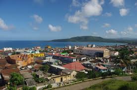
 BARACOA, CUBA, FIRST CAPITAL OF THE ISLAND “CIUDAD PRIMADA”. PHOTOS.
Baracoa is a municipality and city in Guantánamo Province near the eastern tip of Cuba. It was visited by Admiral Christopher Columbus on November 27, 1492, and then founded by the first governor of Cuba, the Spanish conquistador Diego Velázquez de Cuéllar on August 15, 1511. It is the oldest Spanish settlement in Cuba and was its first capital (the basis for its nickname Ciudad Primada, “First City”).
GEOGRAPHY
Baracoa is located on the spot where Christopher Columbus landed in Cuba on his first voyage. It is thought that the name stems from the indigenous Arauaca language word meaning “the presence of the sea”.
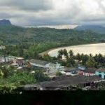
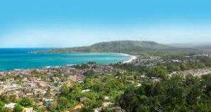
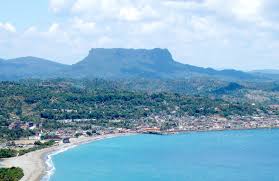
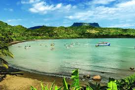
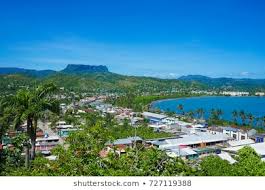
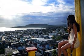
Baracoa lies on the Bay of Honey (Bahía de Miel) and is surrounded by a wide mountain range (including the Sierra del Purial), which causes it to be quite isolated, apart from a single mountain road built in the 1960s. The Baracoa mountain range is covered with Cuban moist forests and Cuban pine forests.
The municipality includes the villages of Barigua, Boca de Yumurí, Cabacú, Cayogüín, Jamal, Jaragua, Los Hoyos, Mabujabo, Mosquitero, Nibujón, Paso Cuba, Sabanilla, Santa María, Vega de Taco, and other minor localities.
Baracoa has a tropical rainforest climate (Af) according to the Köppen climate classification with high temperatures and rainfall throughout the year. Although there is are no true wet or dry seasons, there is a noticeably wetter stretch from October to December.
HISTORY
The original inhabitants of the island were Taíno. They were eradicated by European diseases throughout the island. A local hero is Hatuey, who fled from the Spanish in Hispaniola and raised a Taíno army to fight the Spanish in Cuba. According to the story Hatuey was betrayed by a member of his group and sentenced to burn at the stake. It is said that just before he died a Catholic priest tried to convert him so he would attain salvation; Hatuey asked the priest if Heaven was the place where the dead Spanish go. When he received an answer in the affirmative he told the priest that he would rather go to Hell.
CRUZ DE PARRA
Christopher Columbus landed in Cuba in a place he named Porto Santo. It is generally assumed from his description that this was Baracoa, although there are also claims it was Gibara. But Columbus also described a nearby table mountain, which is almost certainly nearby El Yunque. He wrote in his logbook “the most beautiful place in the world …I heard the birds sing that they will never ever leave this place…”. According to tradition, Columbus put a cross called Cruz de la Parra in the sands of what would later become Baracoa harbor.
Around 15 August 1511 (the official foundation day) Diego Velázquez de Cuéllar was appointed the first governor of Cuba and built a villa here and named the place ‘Nuestra Señora de la Asunción de Baracoa’, thus making Baracoa the first capital of Cuba.[5] In 1518 it received the title of city and the first Cuban bishop was appointed here. As a result, several remains of the Spanish occupation can still be seen here, such as the fortifications El Castillo, Matachín, and La Punta and the cemetery.

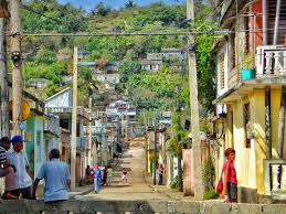
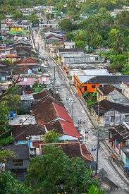
In the 16th and 17th centuries, the isolated location made it a haven for illegal trade with the French and English. During the Jenkin’s Ears War the newly organized Fixed Regiment of Havana appointed in 1744 as Baracoa war lieutenant Luis de Unzaga who managed, thanks to a network of confidants, Irish merchants, and French military, to be warned of possible English attacks, which would allow Baracoa a certain peace and commercial prosperity between Haiti and Cuba despite the time of conflict.[6] At the beginning of the 19th century, many French fled here from the revolution of independence in Haiti, who started growing coffee and cocoa.
From the middle of the 19th century, many expeditions of independence fighters landed here (including Antonio Maceo and José Martí) which greatly helped the independence from Spain in 1902.
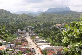
Before the Cuban Revolution, the only access was by sea, but in the 1960s a 120-kilometer-long (75 mi) road from Guantánamo named La Farola was built through the mountains, which was one of the showcases of the revolution. The road had already been planned by the Batista government, but never got built. The highest point of the road is at over 600 m and it passes over 11 bridges.
ECONOMY
The main products in the region are banana, coconut, and cacao. It is Cuba’s main chocolate manufacturing area. Theobroma cacao trees are cultivated under groves of Royal palm on the banks of the Rio Duaba, Rio Yumuri. Ecotourism and birdwatching are important in Baracoa due to the Cuban moist forests.
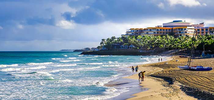
The remote location at the eastern end of the Cuban island has kept the influence of mass tourism quite low, despite the idyllic location. Baracoa can be reached by bus from Santiago de Cuba (four hours) or by plane from Havana (two hours).
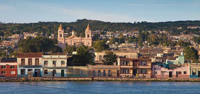
To the east, the Fuerte Matachín (built-in 1802) is still standing and contains houses and museums. To the west the Fuerte La Punta (built-in 1803) houses a restaurant; there is a small beach next to the fort. The third fort, El Castillo, which sits on a steep hill with a commanding view of the town and both bays, is now Hotel El Castillo. The other hotels in Baracoa are Hotel Porto Santo, Hotel La Rusa, Hostal La Habanera and Villa Maguana. There are also a few Casas particulares. The Catedral Nuestra Señora de la Asunción houses the earings[clarification needed] of the Cruz de la Parra, a cross that Cali is supposed to have brought from Spain. Although it has been carbon-dated to approximately that period, it is made from a local type of wood, which means at least part of the story is not correct.
There are two music venues near the central Parque Independencia, the touristy Flan de Queso and the more traditional Casa de la Flana.
Nearby are the rivers Miel and Toa, the latter of which has many waterfalls, the best known of which is ‘el Saltadero’, which is 17 m high.
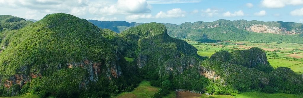
The 575-meter-high (1,886 ft) table mountain el Yunque (the anvil) is 10 km to the west of Baracoa. It is a remnant of a plateau and because of its isolation, it houses several unique species of ferns and palms. The only official and easiest approach to climb it starts at campismo El Yunque (simple lodgings for Cubans only), where a guide is obligatory (about 15 euro).
From Baracoa, it is possible to visit the Parque Nacional Alejandro de Humboldt located about 20 kilometers north.
Salto Fino is the highest waterfall in the Caribbean, located in this municipality, is produced by a sudden drop in the Arroyo del Infierno (Hell’s stream), a tributary of the Quibijan river. That river, along with 71 others, flows into the Toa river, which is the largest river in Cuba. The 305-meter-high Salto Fino waterfall is recorded as the 20th-highest water chute in the world.
GASTRONOMY
Baracoa has typical dishes, such as cucurucho, a mix of coconut and much sugar, and other ingredients like orange, guava, and pineapple and wrapped in a palm leaf. Another is Bacán, which is made from bananas and wrapped in a banana leaf. And of course, there is much chocolate in this cocoa-producing region.
DEMOGRAPHICS
In 2004, the municipality of Baracoa had a population of 81,794. With a total area of 977 km2 (377 sq mi), it has a population density of 83.7/km2 (217/sq mi).

TRANSPORT
Baracoa is the eastern end of Carretera Central, a highway spanning the length of the island of Cuba for 1,435 km, that ends in the village of La Fé, Pinar del Río Province.
AIRPORT
Gustavo Rizo Airport (IATA: BCA, ICAO: MUBA) is a regional airport that serves this town. This is a small airport that usually operates with national flights. Located west of the bay near the Hotel Porto Santo and about 4 km (2½ miles) NNW of Baracoa. Although flights are infrequent, Cubana de Aviación flies here from Santiago de Cuba and Havana.
NOTABLE RESIDENTS
Cuban artist Pablo Borges Delgado was born in Baracoa; Cuban composer Eduardo Davidson was born in Baracoa.
![]()
 BARACOA, CUBA, PRIMERA CAPITAL DE LA ISLA “CIUDAD PRIMADA”. FOTOS.
Baracoa es un municipio y ciudad de la provincia de Guantánamo cerca del extremo oriental de Cuba. Fue visitado por el almirante Cristóbal Colón el 27 de noviembre de 1492, y luego fundado por el primer gobernador de Cuba, el conquistador español Diego Velázquez de Cuéllar el 15 de agosto de 1511. Es el asentamiento español más antiguo de Cuba y fue su primera capital ( la base de su apodo Ciudad Primada, “Primera Ciudad”).
GEOGRAFÍA
Baracoa se encuentra en el lugar donde desembarcó Cristóbal Colón en Cuba en su primer viaje. Se cree que el nombre proviene de la palabra indígena Arauaca que significa “la presencia del mar”.
Baracoa se encuentra en la Bahía de la Miel (Bahía de Miel) y está rodeada por una amplia cadena montañosa (incluida la Sierra del Purial), lo que la hace bastante aislada, a excepción de una única carretera de montaña construida en la década de 1960. La sierra de Baracoa está cubierta por bosques húmedos cubanos y pinares cubanos.
El municipio comprende las localidades de Barigua, Boca de Yumurí, Cabacú, Cayogüín, Jamal, Jaragua, Los Hoyos, Mabujabo, Mosquitero, Nibujón, Paso Cuba, Sabanilla, Santa María, Vega de Taco y otras localidades menores.
Baracoa tiene un clima de selva tropical (Af) según la clasificación climática de Köppen con altas temperaturas y precipitaciones durante todo el año. Aunque no hay verdaderas estaciones húmedas o secas, hay un tramo notablemente más húmedo de octubre a diciembre.
HISTORIA
Los habitantes originales de la isla eran taínos. Fueron erradicados por enfermedades europeas en toda la isla. Un héroe local es Hatuey, quien huyó de los españoles en Hispaniola y levantó un ejército taíno para luchar contra los españoles en Cuba. Según la historia, Hatuey fue traicionado por un miembro de su grupo y condenado a quemarse en la hoguera. Se dice que justo antes de morir un sacerdote católico intentó convertirlo para que alcanzara la salvación; Hatuey preguntó al sacerdote si el cielo era el lugar al que iban los españoles muertos. Cuando recibió una respuesta afirmativa, le dijo al sacerdote que prefería ir al infierno.
CRUZ DE PARRA
Cristóbal Colón aterrizó en Cuba en un lugar al que llamó Porto Santo. En general, se asume por su descripción que se trataba de Baracoa, aunque también hay afirmaciones de que era Gibara. Pero Colón también describió una montaña de la mesa cercana, que casi con certeza está cerca de El Yunque. Escribió en su cuaderno de bitácora “el lugar más hermoso del mundo … Escuché a los pájaros cantar que nunca jamás dejarán este lugar …”. Según la tradición, Colón puso una cruz llamada Cruz de la Parra en las arenas de lo que luego sería el puerto de Baracoa.
Alrededor del 15 de agosto de 1511 (día oficial de la fundación) Diego Velázquez de Cuéllar fue nombrado primer gobernador de Cuba y construyó una villa aquí y llamó al lugar ‘Nuestra Señora de la Asunción de Baracoa’, convirtiendo a Baracoa en la primera capital de Cuba. [ 5] En 1518 recibió el título de ciudad y aquí fue nombrado el primer obispo cubano. Como resultado, todavía se pueden ver aquí varios restos de la ocupación española, como las fortificaciones El Castillo, Matachín, La Punta y el cementerio.
En los siglos XVI y XVII, la ubicación aislada la convirtió en un refugio para el comercio ilegal con franceses e ingleses. Durante la Guerra de las Orejas de Jenkin el recién organizado Regimiento Fijo de La Habana nombró en 1744 como lugarteniente de guerra de Baracoa a Luis de Unzaga, quien logró, gracias a una red de confidentes, comerciantes irlandeses y militares franceses, ser advertido de posibles ataques ingleses, lo que permitiría Baracoa una cierta paz y prosperidad comercial entre Haití y Cuba a pesar de la época de conflicto. [6] A principios del siglo XIX, muchos franceses huyeron aquí de la revolución de la independencia en Haití, quienes comenzaron a cultivar café y cacao.
Desde mediados del siglo XIX, muchas expediciones de luchadores por la independencia desembarcaron aquí (incluidos Antonio Maceo y José Martí) que ayudaron mucho a la independencia de España en 1902.
Antes de la Revolución Cubana, el único acceso era por mar, pero en la década de 1960 se construyó una carretera de 120 kilómetros desde Guantánamo llamada La Farola a través de las montañas, que fue una de las vitrinas de la revolución. El camino ya había sido planeado por el gobierno de Batista, pero nunca se construyó. El punto más alto de la carretera se encuentra a más de 600 my pasa por 11 puentes.
ECONOMÍA
Los principales productos de la región son el banano, el coco y el cacao. Es la principal zona de fabricación de chocolate de Cuba. Los árboles de cacao Theobroma se cultivan bajo arboledas de palma real en las orillas del río Duaba, río Yumuri. El ecoturismo y la observación de aves son importantes en Baracoa debido a los bosques húmedos cubanos.
La ubicación remota en el extremo oriental de la isla cubana ha mantenido la influencia del turismo de masas bastante baja, a pesar de la ubicación idílica. Se puede llegar a Baracoa en bus desde Santiago de Cuba (cuatro horas) o en avión desde La Habana (dos horas).
Al este, el Fuerte Matachín (construido en 1802) todavía está en pie y contiene casas y museos. Al oeste el Fuerte La Punta (construido en 1803) alberga un restaurante; hay una pequeña playa al lado del fuerte. El tercer fuerte, El Castillo, que se asienta sobre una colina empinada con una vista imponente de la ciudad y ambas bahías, es ahora el Hotel El Castillo. Los otros hoteles en Baracoa son Hotel Porto Santo, Hotel La Rusa, Hostal La Habanera y Villa Maguana. También hay algunas Casas particulares. La Catedral Nuestra Señora de la Asunción alberga los pendientes de la Cruz de la Parra, una cruz que se supone que Cali trajo de España. Aunque se ha fechado con carbono aproximadamente en ese período, está hecho de un tipo de madera local, lo que significa que al menos parte de la historia no es correcta.
Hay dos locales de música cerca del céntrico Parque Independencia, el turístico Flan de Queso y la más tradicional Casa de la Flana.
Muy cerca se encuentran los ríos Miel y Toa, el último de los cuales tiene muchas cascadas, la más conocida de las cuales es ‘el Saltadero’, que tiene 17 m de altura.
El Yunque (el yunque), de 575 metros de altura, se encuentra a 10 km al oeste de Baracoa. Es un remanente de una meseta y debido a su aislamiento, alberga varias especies únicas de helechos y palmeras. El único acceso oficial y más fácil para escalar comienza en el campismo El Yunque (alojamientos sencillos solo para cubanos), donde es obligatorio un guía (unos 15 euros).
Desde Baracoa, es posible visitar el Parque Nacional Alejandro de Humboldt ubicado a unos 20 kilómetros al norte.
El Salto Fino es la cascada más alta del Caribe, ubicada en este municipio, es producida por una caída repentina en el Arroyo del Infierno, afluente del río Quibiján. Ese río, junto con otros 71, desemboca en el río Toa, que es el río más grande de Cuba. La cascada Salto Fino de 305 metros de altura está registrada como el vigésimo tobogán de agua más alto del mundo.
GASTRONOMÍA
Baracoa tiene platos típicos, como el cucurucho, una mezcla de coco y mucha azúcar, y otros ingredientes como naranja, guayaba y piña y envueltos en una hoja de palma. Otro es el Bacán, que se elabora con plátanos y se envuelve en una hoja de plátano. Y, por supuesto, hay mucho chocolate en esta región productora de cacao.
DEMOGRAFÍA
En 2004, el municipio de Baracoa tenía una población de 81.794. Con una superficie total de 977 km2 (377 millas cuadradas), tiene una densidad de población de 83,7 / km2 (217 millas cuadradas).

TRANSPORTE
Baracoa es el extremo oriental de la Carretera Central, una carretera que se extiende a lo largo de la isla de Cuba por 1.435 km, que termina en la localidad de La Fé, provincia de Pinar del Río.
AEROPUERTO
El Aeropuerto Gustavo Rizo (IATA: BCA, ICAO: MUBA) es un aeropuerto regional que da servicio a esta localidad. Este es un aeropuerto pequeño que generalmente opera con vuelos nacionales. Ubicado al oeste de la bahía cerca del Hotel Porto Santo ya unos 4 km (2½ millas) al NO de Baracoa. Aunque los vuelos son poco frecuentes, Cubana de Aviación vuela aquí desde Santiago de Cuba y La Habana.
RESIDENTES DESTACADOS
El artista cubano Pablo Borges Delgado nació en Baracoa; El compositor cubano Eduardo Davidson nació en Baracoa.
Agencies/ Wiki/ Internet Photos/ Arnoldo Varona/ www.TheCubanHistory.com
THE CUBAN HISTORY, HOLLYWOOD.
![]()