 AMANCIO, Cuba, Municipality and Town in the Tunas Province. PHOTOS. * AMANCIO, Cuba, Municipio y Pueblo en la Provincia de las Tunas. PHOTOS.


AMANCIO, CUBA, MUNICIPALITY, AND TOWN IN LAS TUNAS PROVINCE. PHOTOS
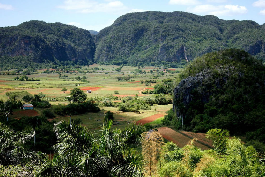
Amancio (Spanish pronunciation: [aˈmansjo]) is a municipality and town in the Las Tunas Province of Cuba. It is located in the southwestern part of the province and opens to the Gulf of Guacanayabo to the south.
HISTORY
The aboriginal community in the territory
When observing the archaeological map of Amancio with the sites so far located, we see that the appropriation groups (preagroalfarero) occupied the areas near the coasts and spread to the inland, very close to the rivers and streams existing in the municipality.
The groups of productions (agro-pottery), although only small elements have been found, there is a coincidence of them, which are located 12 and 22 km from the coast and close to rivers and streams, it seems that they did not reach a greater degree of development, finding objects of art and domestic use, such as hammers, mortars, laces, and sheets of flint, remains of clay and birene pots, which were used to make cassava.
In 1860, at public auction, the Hato Viejo herd was sold by its owner Velasco for 3,500 pesos to Salvador Cisneros Betancourt (“Marquis” of Santa Lucía), who had the land until 1890 when he sold it to Señor Rionda y Polleda. Also, this man bought that same year the lands of the Yáquimo farm with an extension of 280 caballerias. Later, the widow of Rionda sold them to the Tierra Azúcar company (Cuban-American) and this company sold it to The Francisco Sugar Company, thus beginning the American influence in our municipality, with the clearing of forests and the planting of sugar canes to the new plant that began its execution in 1899, 16 km from the jetty of the Guayabal spring or Cayo Romero.

DEMOGRAPHICS
In 2004, Amancio had a population of 41,523. With a total area of 857 km2 (331 sq mi), it has a population density of 48.5/km2 (126/sq mi).
Littoral zone
To the south corresponds the coasts of the Gulf of Guacanayabo, where the port of Guayabal is located with a bulk sugar terminal, here the sea has low depths, calm waters, and innumerable biotic resources.
Plains area
This ranges from the coastal zone to the inland, from the limits of the coastline up to 22 km to the north of the region, counting on the Sevilla, Yáquimo river, and the Matamacos and Naranjo streams. This entire area had extensive forests that began to disappear from 1899 with the introduction of the sugar industry; these forests and animal sediments were enriching the soils with organic matter.
Small elevations area
To the northwest, there are small elevations that relatively modify the terrain and define an important degree in the relief.
Area code(s) +53-31

* RECOMIENDENOS A SUS AMISTADES * PREFIERA A NUESTROS SPONSORS.*
![]()

AMANCIO, CUBA, MUNICIPIO Y PUEBLO EN LA PROVINCIA DE LAS TUNAS. FOTOS
Amancio (pronunciación en español: [aˈmansjo]) es un municipio y pueblo de la provincia de Las Tunas en Cuba. Se ubica en la parte suroeste de la provincia y se abre al Golfo de Guacanayabo al sur.
HISTORIA
La comunidad aborigen en el territorio
Al observar el mapa arqueológico de Amancio con los sitios hasta el momento localizados, vemos que los grupos de apropiación (preagroalfarero) ocuparon las áreas cercanas a las costas y se extendieron hacia el interior, muy cerca de los ríos y arroyos existentes en el municipio.
Los grupos de producciones (agro-alfarería), si bien solo se han encontrado pequeños elementos, hay coincidencia de ellos, que se ubican a 12 y 22 km de la costa y cerca de ríos y arroyos, parece que no llegaron a un mayor grado de desarrollo, encontrando objetos de arte y uso doméstico, como martillos, morteros, cordones y láminas de pedernal, restos de barro y vasijas de bireno, que se utilizaban para la elaboración de yuca.

En 1860, en subasta pública, el rebaño de Hato Viejo fue vendido por su dueño Velasco por 3500 pesos a Salvador Cisneros Betancourt (“Marqués” de Santa Lucía), quien tuvo la tierra hasta 1890 cuando se la vendió al Señor Rionda y Polleda. Además, este hombre compró ese mismo año las tierras de la finca Yáquimo con una extensión de 280 caballerías. Posteriormente, la viuda de Rionda los vendió a la empresa Tierra Azúcar (Cubano-Americana) y esta empresa la vendió a The Francisco Sugar Company, iniciando así la influencia americana en nuestro municipio, con la tala de bosques y la siembra de caña de azúcar a la nueva planta que inició su ejecución en 1899, a 16 km del malecón del manantial Guayabal o Cayo Romero.
DEMOGRAFÍA
En 2004, Amancio tenía una población de 41.523. Con una superficie total de 857 km2 (331 millas cuadradas), tiene una densidad de población de 48,5 / km2 (126 / mi2).
Zona litoral
Al sur corresponde las costas del Golfo de Guacanayabo, donde se ubica el puerto de Guayabal con una terminal de azúcar a granel, aquí el mar tiene profundidades bajas, aguas tranquilas e innumerables recursos bióticos.

Área de llanuras
Se extiende desde la zona costera hacia el interior, desde los límites del litoral hasta los 22 km al norte de la comarca, contando con el río Sevilla, el río Yáquimo y los arroyos Matamacos y Naranjo. Toda esta zona contaba con extensos bosques que comenzaron a desaparecer a partir de 1899 con la introducción de la industria azucarera; estos bosques y sedimentos animales estaban enriqueciendo los suelos con materia orgánica.
Área de pequeñas elevaciones
Al noroeste, hay pequeñas elevaciones que modifican relativamente el terreno y definen un grado importante en el relieve.
Código (s) de área + 53-31
Agencies/ Wiki/ Ecured/ Internet Photos/ Arnoldo Varona/ www.TheCubanHistory.com
THE CUBAN HISTORY, HOLLYWOOD.

* RECOMIENDENOS A SUS AMISTADES * PREFIERA A NUESTROS SPONSORS.*
![]()