
 CUBA: Four of the Most Outstanding Natural Beauties of the Island. PHOTOS. * CUBA: Cuatro de las Bellezas Naturales más destacadas de la Isla. PHOTOS.
CUBA: FOUR OF THE MOST OUTSTANDING NATURAL BEAUTIES OF THE ISLAND. PHOTOS
Although it is true that making a list of the most beautiful Cuban landscapes is truly difficult due to the variety and quantity of beautiful scenery, each one also has its predilection.
If we take into account the theme of nature trips, Baracoa in eastern Cuba and the Sierra del Escambray in the center of the country can well be marked as the most significant and beautiful, due to its fantastic landscape and greenery.
1. PINAR DEL RÍO
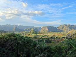
Pinar del Río is a magical region. Where green stands out above any other color.
For Cubans, in addition to the westernmost province of the island, it symbolizes the homeland of the best tobacco in the world, there the leaves are harvested for the layer of cigars, where a true natural gem is treated with passion by farmers.
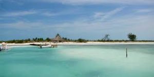
Pinar del Río is that and much more, as reflected by travelers from all over the world and also has some charms that it is good to exemplify, a first stopover point could well be Cayo Levisa, 27 kilometers from La Palma, in the north of Pinar del Río, from the Palma Rubia pier; There the boats are boarded to Cayo Levisa, three nautical miles from the mainland. Bathed by the Caribbean Sea, exhibiting 4 kilometers of virgin beaches, with fine white sand.
The starting point to reach the westernmost part of Cuba is La Bajada, a small community of around 100 inhabitants, dedicated mainly to forestry work, with very experienced knowledge of nature conservation. There, you can travel to the Guanahacabibes National Park, declared a World Biosphere Reserve by UNESCO in 1987, with 39,400 hectares. Paradise where more than 670 species of plants live, 15 of them endemic, has small beaches wrapped in stories of pirates and hidden treasures.
2- JARDINES DE LA REINA
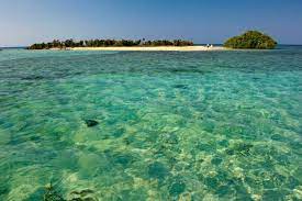
It is the Jardines de la Reina National Park, the largest on the island in terms of sea area, with 2,170 square kilometers. It is made up of the archipelago of the same name and the waters that surround it.
Therefore, the Jardines de la Reina Archipelago constitutes one of the four that exist in Cuba, third in extension, and the most natural. From the front, it covers about 150 kilometers and was named Jardines de la Reina by the Genoese explorer Christopher Columbus in honor of the Queen of Spain. It consists of an archipelago of narrow and small keys, most of them on the edge of the insular platform between 30 and 80 kilometers, south of the Ciego de Ávila and Camagüey provinces, formed by mangroves, scrub, much vegetation, and strips of low sandy dunes.
These keys stand out for their natural formations and relatively larger extensions such as Caballones, Anclitas, Caguamas, Cinco Balas, Algodones and Bretón. In such spaces there is a wide range of insects, spiders, reptiles, and birds; in addition to abundant populations of iguanas and jutías, all on small white sand beaches.
In that area, it is the main spawning scene of the four species of marine turtles in Cuba and presents the main populations of cobos (Strombus gigas) in the country.
Large specimens of platform fish and some others from deep waters appear in the area, among them: sharks such as the Hardhead (Carcharinus falciformis), Playful (Carcharinus perezi) and the Whale Shark (Rhincodon typus).
3- BARACOA
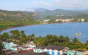
Belonging to the province of Guantánamo, Baracoa, it sits next to the sea and stands out for its natural beauties.
Known as the First City of Cuba, Baracoa is all magic of colors and adventures, the first town on that island, recognized as an essential place to visit, a festival of colors. Nuestra Señora de la Asunción de Baracoa is its name, with urban constructions encompassing a small space surrounded by a lot of rugged coastlines, foliage, mountains, and rivers.
The Taino Indians (descendants of the Arruacas or Arauacos) were the quintessential settlers of the place when Admiral Christopher Columbus arrived in 1492 and on the same voyage of discovery when he set foot on the island for the second time, he did so in that area. They say that the word Baracoa is aboriginal and means “the existence of the sea” in frank allusion of its original inhabitants to a presence of a marine environment everywhere, very contrasting with the mountains and river arteries.
Baracoa, the easternmost of the nation – about a thousand kilometers to the east of the capital – was founded by Diego Velázquez on August 15, 1511, becoming the first capital and first bishopric of the island. Then it lost that condition and the capital were transferred to Santiago de Cuba first, and then to Havana, due to the needs of the Spanish colonization.
It is a truly picturesque place that covers 921.2 square kilometers in which about 82 thousand people from Baracoa live, much of it in the urban region and the rest in the rural environment.
This area belongs to the Sagua-Baracoa mountain system, famous for its dense foliage. In the country, there are only two areas where the vegetation remains comparable to its origins: the center of the Island (Sierra del Escambray) and Baracoa.
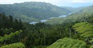
4- ESCAMBRAY

Guamuhaya Massif. Escambray. A truly wonderful place, with a particular climate in the midst of the always latent heat of Cuba.
The mountains of Guamuhaya, also known as Escambray, are located towards the south of the central region of Cuba and show a vigorous relief, only surpassed by that of the Sierra Maestra.
Some of its peaks exceed a thousand meters in altitude, extended for about 80 kilometers in length, and divided into two massifs by the Agabama river: the western one is made up of the Sierra de Trinidad, and the eastern portion forms the Sierra de Sancti Spíritus.
The name of this mountainous massif is derived from the Arawak aboriginal language in which means source or birth; mu, development and have, to associate, therefore this name is part of the archaeological legacy of the first inhabitants of Cuba.
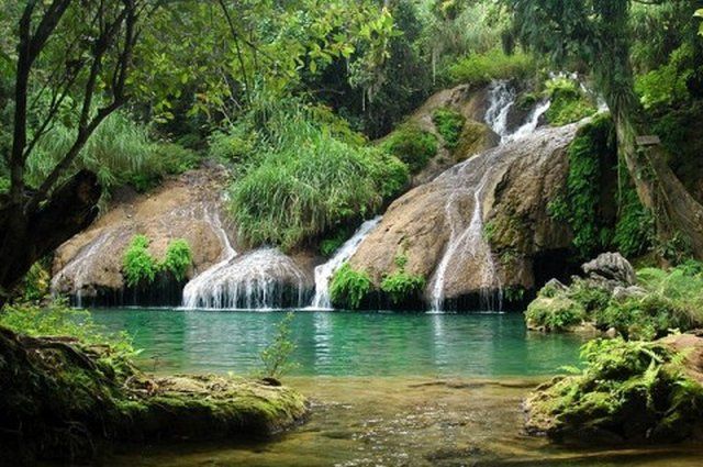
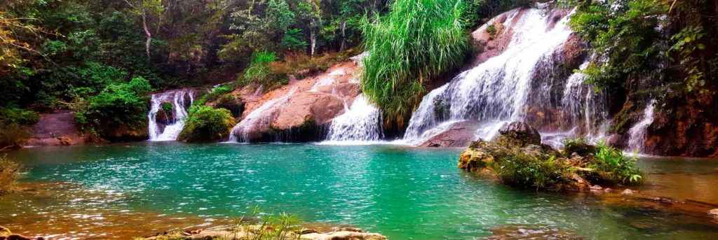
In turn, some open valleys in the orographic massif do not offer surface drains, but underground, through caves. Some drains of these basins, almost closed, are made through narrow canyons and waterfalls as was the case of the Hanabanilla River, around which there are numerous interpretive trails of nature.
The Escambray region is a mountainous massif with a territorial extension of 1642.4 square kilometers, located in the territory of the three central provinces of the country; It spans three municipalities in the province of Sancti Spíritus (951.3 square kilometers) and one of the provinces of Villa Clara (291.0) and Cienfuegos (401.0).
RECOMIENDENOS A SUS AMISTADES * PREFIERA A NUESTROS SPONSORS.
![]()
CUBA: CUATRO DE LAS BELLEZAS NATURALES MAS DESTACADAS DE LA ISLA. PHOTOS

Si bien es cierto que hacer una lista con los mas bellos paisajes cubanos es verdaderamente difícil por la variedad y cantidad de escenarios hermosos, también cada cual tiene su predilección.
Si tomamos en cuenta el tema de los viajes de naturaleza bien se puede marcar a Baracoa en el oriente cubano y a la Sierra del Escambray en el centro del país, como los más significativos y hermosos, por su fantástico paisaje y verdor.
1. PINAR DEL RÍO
Pinar del Río es una región mágica. Donde el verde resalta por encima de cualquier otro color.
Para los cubanos, además de la provincia más occidental de la Isla, simboliza la patria del mejor tabaco del mundo, allí se cosechan las hojas para la capa de los puros, donde se trata con pasión por parte de los agricultores una verdadera joya natural.
Pinar del Río es eso y mucho más, tal y como lo reflejan viajeros llegados de todas partes del mundo y además posee algunos encantos que es bueno ejemplificar, un primer punto de escala bien podría ser Cayo Levisa, a 27 kilómetros de La Palma, en el norte de Pinar del Río, desde el embarcadero de Palma Rubia; allí se abordan las lanchas hacia Cayo Levisa, a tres millas náuticas de tierra firme. Bañado por el mar Caribe, exhibiendo 4 kilómetros de playas vírgenes, de fina arena blanca.
El punto de partida para llegar a la porción más oeste cubana es La Bajada, una pequeña comunidad de alrededor de 100 habitantes, dedicados principalmente a trabajos forestales, con un conocimiento muy experimentado de la conservación de la naturaleza. Por allí, se puede viajar al Parque Nacional de Guanahacabibes, declarado Reserva Mundial de La Biosfera por la UNESCO en 1987, con 39 mil 400 hectáreas. Paraíso donde habitan más 670 especies de plantas, 15 de ellas endémicas, posee pequeñas playas envueltas en historias de piratas y tesoros escondidos.
2- JARDINES DE LA REINA
Se trata del Parque Nacional Jardines de la Reina, el mayor de la ínsula en cuanto a extensión de mar, con dos mil 170 kilómetros cuadrados. Está integrado por el archipiélago del mismo nombre y las aguas que lo rodean.
Por tanto, el Archipiélago Jardines de la Reina constituye uno de los cuatro que existen en Cuba, tercero en extensión y el más natural. De frente abarca alrededor de 150 kilómetros y fue nombrado Jardines de la Reina por el explorador genovés Cristóbal Colón en honor a la reina de España. Consiste en un archipiélago de cayos estrechos y pequeños, la mayor parte de ellos en el borde de la plataforma insular entre 30 y 80 kilómetros, al sur de las provincias Ciego de Ávila y Camagüey, formados por manglares, matorrales, mucha vegetación y franjas de dunas arenosas bajas.
Estos cayos resaltan por sus formaciones naturales y extensiones relativamente mayores como Caballones, Anclitas, Caguamas, Cinco Balas, Algodones y Bretón. En tales espacios existe una amplia gama de insectos, arañas, reptiles y aves; además de abundantes poblaciones de iguanas y jutías, todo en pequeñas playas de blancas arenas.
En esa zona es el principal escenario de desove de las cuatro especies de tortugas marinas de Cuba y presenta las principales poblaciones de cobos (Strombus gigas) del país.
Aparecen por el lugar grandes ejemplares de peces de plataforma y algunos otros de aguas profundas, entre estos: tiburones como el Cabeza dura (Carcharinus falciformis), Juguetón (Carcharinus perezi) y el Tiburón ballena (Rhincodon typus).
3- BARACOA

Perteneciente a la provincia de Guantánamo, Baracoa, se asienta junto al mar y destaca por sus bellezas naturales.
Conocida como la Ciudad Primada de Cuba, Baracoa es toda magia de colores y aventuras, la primera villa de esa Isla, reconocida como un sitio imprescindible a visitar, una fiesta de colores. Nuestra Señora de la Asunción de Baracoa es su nombre, con construcciones urbanas abarcadoras de un pequeño espacio rodeado de mucha costa abrupta, follaje, montañas y ríos.
Los indios taínos (descendientes de los arruacas o arauacos) eran los pobladores por excelencia del lugar cuando el almirante Cristóbal Colón llegó en 1492 y en el mismo viaje del descubrimiento, al pisar por segunda ocasión la isla, lo hiciera en esa área. Cuentan que el vocablo de Baracoa es aborigen y quiere decir “existencia de mar” en franca alusión de sus pobladores originales a una presencia de ambiente marinero por todos lados, muy contrastante con las montañas y las arterias fluviales.
Baracoa, la más oriental de la nación -a unos mil kilómetros hacia el este de la capital- fue fundada por el Diego Velázquez el 15 de agosto de 1511, constituyéndose como primera capital y primer obispado de la ínsula. Luego perdió esa condición y fue trasladada la capital a Santiago de Cuba primero, y luego a La Habana, por necesidades de la colonización española.
Es un lugar verdaderamente pintoresco que abarca 921,2 kilómetros cuadrados en los que viven unos 82 mil baracoesos, buena parte en la región urbana y el resto en el entorno rural.
Esta zona pertenece al sistema montañoso Sagua-Baracoa, famoso por su tupido follaje. En el país existen solamente dos áreas donde la vegetación se mantiene comparable con los orígenes: el centro de la Isla (Sierra del Escambray) y Baracoa.
4- ESCAMBRAY
Macizo de Guamuhaya. Escambray. Un sitio verdaderamente maravilloso, con un clima particular en medio del calor siempre latente de Cuba.
Las montañas de Guamuhaya, también denominadas Escambray, están localizadas hacia el sur de la región central de Cuba y muestran un vigoroso relieve, sólo superado por el de la Sierra Maestra.
Algunas de sus cumbres sobrepasan los mil metros de altitud, extendidas en cerca de 80 kilómetros de largo y divididas en dos macizos por el río Agabama: el occidental está constituido por la Sierra de Trinidad, y la porción oriental forma la Sierra de Sancti Spíritus.
La denominación de este macizo montañoso es derivada de la lengua aborigen arahuaco en el que gua significa fuente o nacimiento; mu, desarrollo y haya, asociarse, por tanto este apelativo es parte del legado arqueológico de los primeros habitantes de Cuba.
A su vez, algunos valles abiertos en el macizo orográfico no ofrecen desagües superficiales, sino subterráneos, a través de cavernas. Algunos drenajes de esas cuencas, casi cerradas, se realizan a través de cañones estrechos y de cascadas como era el caso del río Hanabanilla, en cuyo derredor existen numerosos senderos interpretativos de la naturaleza.
La región del Escambray es un macizo montañoso con una extensión territorial de 1642,4 kilómetros cuadrados, ubicado en territorio de las tres provincias centrales del país; se extiende por tres municipios de la provincia de Sancti Spíritus (951,3 kilómetros cuadrados) y uno de las provincias de Villa Clara (291,0) y Cienfuegos (401,0).
Agencies/ Wiki/ ExcelenciasNews/ Internet Photos/ Arnoldo Varona/ www.TheCubanHistory.com
THE CUBAN HISTORY, HOLLYWOOD.

RECOMIENDENOS A SUS AMISTADES * PREFIERA A NUESTROS SPONSORS.
![]()