
 BACUNAYAGUA Bridge, Matanzas, Cuba: one of the Wonder of the Cuban Civil Engineering. PHOTOS. * PUENTE de BACUNAYAGUA, Matanzas, Cuba: una de las Maravillas de la Ingeniería Civil Cubana. PHOTOS.
PUENTE DE BACUNAYAGUA, MATANZAS, CUBA: UNA DE LAS MARAVILLAS DE LA INGENIERÍA CIVIL CUBANA. FOTOS

El Puente de Bacunayagua, construido en los límites de la provincia de La Habana y Matanzas su construcción es históricamente un cruce con la Vía Blanca (la carretera que une Ciudad de La Habana y Varadero), iniciada por el gobierno de Carlos Prío Socarrás, con el propósito de acortar la distancia entre Matanzas y La Habana. El cruce del cañón se inauguró en septiembre de 1959 y, a 110 metros (360 pies) sobre el fondo del valle, se encuentra el puente más alto de Cuba. Los cubanos la consideran una de las siete maravillas de la ingeniería civil cubana. Fue diseñado por Luis Sáenz Duplace y construido bajo la dirección del Ingeniero Civil Manuel (Manolo) Arvesu.
El puente solía dividir las provincias de La Habana y Matanzas, pero después de la reorganización de 2010, ahora divide la provincia de Matanzas de la nueva provincia de Mayabeque (la más pequeña de la isla, a excepción de la propia ciudad de La Habana).
Un total de 41 columnas sostienen el puente de Bacunayagua, las que en su momento fueron las más esbeltas del mundo hechas de hormigón.
CONSTRUCCIÓN DEL PUENTE BACUNAYAGUA
En 1956 se iniciaron las obras de construcción del puente, catalogado en esa época como una obra colosal, no sólo por su extensión sino por la altura sobre un inmenso acantilado. Sus columnas poseen una pila de 22,50 metros cada una, con un ancho de un metro por 1,60 metros, y algunas alcanzan los 42 metros de altura.
Sobre sus cabezales se encuentran 6 vigas que pesan cada una 47 toneladas, y que fueron fundidas en el mismo lugar donde se construía el puente. En total el puente tiene una altura de 103 metros, con una longitud de 314 metros y un ancho de 17. No fue terminado hasta octubre de 1959, cuando se fijó oficialmente la apertura de las vías para la comunicación entre La Habana y Matanzas.
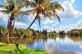
Este imponente paso que dista 18 kilómetros al oeste de la ciudad de Matanzas y establece el límite territorial con la provincia de La Habana. Al norte del puente, se divisa el inmenso mar; el cauce y desembocadura de lo que debió ser el cauce de un caudaloso río en tiempo remoto, y al sur, el extenso y exuberante Valle de Yumurí.

La importancia de ese cruce para la Vía Blanca reside en que es la conexión más cercana y directa, para el hermoso paisaje de la costa norte cubana, entre el Túnel de la capital del país y la Ciudad Balneario de Varadero.
La belleza del entorno de Bacunayagua, favorecida por la ejecución de ese avanzado proyecto, alterna con multitud de farallones, laderas y manglares, refugio natural de gran importancia ornitológica donde conviven 74 especies de aves, 16 de reptiles y ocho de anfibios. En el ecosistema de manglares de esta zona aparecen formaciones vegetales como el brezal costero xeroformo y el bosque semideciduo, además de una rica y variada fauna con alto porcentaje de endemismo.
La magnitud y espléndida imagen del lugar se puede apreciar perfectamente desde el Mirador, ubicado en un alzado al extremo oeste de la maravillosa obra.
Todavía hoy, esta asombrosa maravilla arquitectónica cubana se eleva sobre el valle del río Yumurí, y como se encuentra en un punto que une el balneario más grande conocido como Varadero con la capital La Habana.
![]()
BACUNAYAGUA BRIDGE, MATANZAS, CUBA: ONE OF THE WONDER OF THE CUBAN CIVIL ENGINEERING. PHOTOS
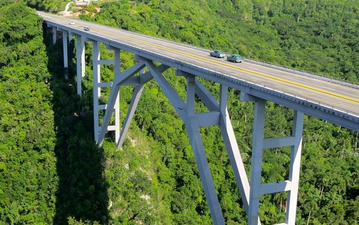
The Bridge of Bacunayagua, built in the borders of Havana Province and Matanzas its construction is historically a crisscross with the Via Blanca (the highway that connects Havana City and Varadero), begun by Carlos Prío Socarrás´ government, with the purpose of shortening the distance between Matanzas and Havana. Crossing the canyon was inaugurated in September 1959, and at 110 metres (360 ft) above the valley floor is the highest bridge in Cuba. Cubans consider it one of the seven wonders of Cuban civil engineering. It was designed by Luis Sáenz Duplace and built under the leadership of Civil Engineer Manuel (Manolo) Arvesu.
The bridge used to divide the provinces of La Habana and Matanzas, but after the reorganization of 2010, it now divides Matanzas Province from the new Mayabeque Province (the island’s smallest, except for the city of Havana itself).
A total of 41 columns sustains the bridge of Bacunayagua, those that were in its moment the most slender in the world made of concrete.
CONSTRUCTION OF THE BACUNAYAGUA BRIDGE
In 1956 the works of construction of the bridge began, classified during that time as a colossal work, not only for its extension but for the height on an immense cliff. Its columns possess a pile of 22.50 meters each one, with a width of a meter for 1.60 meters, and some reach the 42 meters high.
On its bolsters there are 6 beams that weigh each one 47 tons, and that they were fused in the same place the bridge was being built. In total the bridge has a height 103 meters, with a longitude 314 meters and a width of 17. It did not go finished until October 1959, when the opening of the paths for the communication between Havana and Matanzas was officially settled.

This impressive step that is 18 kilometers away to the west of the city of Matanzas and it establishes the territorial limit with the county of Havana. To the north of the bridge, the immense sea is sighted; the channel and the outlet of what should be the bed of a mighty river in a remote time, and to the south, the extensive and exuberant Valley of Yumurí.
The importance of that crossing for the Via Blanca resides in that is the nearest and direct connection, for the beautiful landscape of the Cuban north coast, between the Tunnel of the capital of the country and the City Spa of Varadero.
The beauty of the environment of Bacunayagua, favored by the execution of that advanced project, alternates with multitude of headlands, hillsides and mangroves, natural refuge of great ornithological importance where 74 species of birds cohabit with 16 of reptiles and eight of amphibians. In the ecosystem of swamp of this area vegetable formations appear as the heath coastal xeroformo and the forest semideciduo, besides a rich and varied fauna with high percent of endemism.
The magnitude and splendid image of the place can be appreciated perfectly from the Mirador, located in an elevation to the end west of the wonderful work.
Still today, this amazing Cuban architectural marvel stands tall above the Yumurí River Valley, and as it is on a point which links the biggest beach resort known as Varadero with the capital Havana.
Agencies/ InsightCuba/ BacunayaguaBridge/ Extractos/ Excerpts/ Internet Photos/ Arnoldo Varona/ www.thecubanhistory.com
THE CUBAN HISTORY, HOLLYWOOD.
![]()