

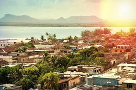
 HOLGUIN, capital y ciudad de la Provincia Oriental de Cuba. Loma de la Cruz. PHOTOS. * HOLGUIN, capital and city of the Eastern Province of Cuba. Loma de la Cruz. PHOTOS.
HOLGUIN, CAPITAL Y CIUDAD DE LA PROVINCIA ORIENTAL DE CUBA. LOMA DE LA CRUZ. PHOTOS

Holguín es la tercera provincia más grande de Cuba, con una extensión que representa el 8,6 % de la superficie total de la isla, contando con 14 municipios, en los cuales se localizan 1112 asentamientos poblacionales, de ellos 43 urbanos.
En Cuba la nombran de varias maneras: «provincia de Holguín» , «provincia Holguín» o simplemente «Holguín».
La provincia de Holguín está situada al norte de la parte Oriental del país. Es la tercera en extensión con 9300,6 km², siendo el municipio Mayarí el más extenso con 1308,4 km². El extremo más septentrional es la Playa Juan Antonio, en Gibara, el meridional Arroyo Blanco en Sagua de Tánamo, el oriental la Boca del Río Jiguaní en Moa y el más occidental Sabanazo en el Municipio Calixto García. Limita al norte con el Océano Atlántico, al sur con las Provincias de Granma y Santiago de Cuba, al este con la de Guantánamo y al oeste con la de Las Tunas.
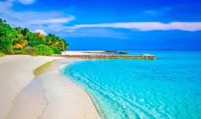
Holguín tiene una situación geográfica privilegiada, posee 350 km de costas. Presenta hermosas playas e interesantes accidentes geográficos, como son las bahías de Gibara, Banes y Nipe, esta última la mayor de Cuba y considerada una de las mayores del mundo.
Con los límites geográficos, al norte: Océano Atlántico. Al este: Provincia Guantánamo. Al sur: Provincias Santiago de Cuba y Granma. Al oeste: Provincia Las Tunas.
Cono su río de mayor longitud: el Mayarí con 110 km de longitud, 1231 km² de área; y 15,8 m²/s de gasto.
En su geografía física predominan las alturas de Maniabón, Llanura del Cauto, Llanura de Nipe, y las Montañas de Nipe-Sagua-Baracoa. Su hidrografía está representada por los ríos Mayarí, Gibara, Sagua de Tánamo, Tacajó y los embalses Gibara, Cacoyugüin, Sabanilla y las bahías de Gibara, Banes y Nipe. Prevalecen los suelos fersialíticos rojo pardusco ferromagnesial, fersialíticos pardo rojizo, y oscuro plástico gleyzado.
HOLGUÍN Y SUS MUNICIPIOS
Fue fundado como San Isidoro de Holguín en 1545, y lleva el nombre de su fundador, el capitán García Holguín, un oficial del ejército español. Antes de 1976, Holguín se encontraba en la provincia de Oriente.
El municipio se divide en los barrios de Aguarás, Aguas Claras, Alcalá, Arroyo Blanco del Sur, Báguanos, Cabezuelas, Cacocún, Calderón, Camazán, Cauto del Cristo, Corralillo, Cruces de Purnio, Damián, Floro Pérez, Gibara, Guabasiabo, Guayabal , Guirabo, Haticos del Purial, La Aguada, La Cuaba, La Palma, La Rioja, Las Calabazas, Managuaco, Melones, Norte, Omaja, Purnio, San Agustín, San Andrés, San Francisco, San Juan, San Lorenzo, Santa Rita, Sur, Tacámara, Tasajeras, Uñas, Uñitas, Velasco, Yareyal y Yayal.
Hay varios pequeños parques de la ciudad como Parque Infantil, Parque San José, Parque San Isidoro, Parque Martí entre otros, el más céntrico Calixto García en el centro de la ciudad. Muy cerca se encuentran las galerías Centro Provincial de Arte y Bayado, una biblioteca, el club Casa de la Trova, el cine Martí, el Teatro Eddy Suñol, el Museo de la Provincia La Periquera, un museo de la ciencia y un museo de historia. Desde el cerro Loma de la Cruz, donde se instala un gran crucifijo, que puede ascender por sus 450 escalones, se puede supervisar toda la ciudad.
Cerca de la ciudad se encuentra el “Farallón Mayar de Seboruco”. Sitio de gran importancia para sus cuevas arqueológicas extremadamente valiosas. Han encontrado evidencia de cultura protoarcaica. Tiene pictogramas en buen estado, dibujados en estilo blanco y negro con trazos bastante abstractos y lineales, considerado el lugar más arcaico del asentamiento aborigen en Cuba.

FLORA Y FAUNA
La provincia de Holguín posee una de las floras más ricas en especies endémicas de Cuba, debido a la presencia de grandes extensiones de su territorio cubiertas por formaciones vegetales que se desarrollan sobre suelos originados a partir de rocas ultrabásicas (serpentinas). Estas formaciones van desde los manglares en las zonas costeras, hasta selvas tropicales, las que son conocidas como cuabales y charrascales.
En la provincia los cuabales se presentan fundamentalmente bordeando la ciudad de Holguín y cubriendo gran parte de las llanuras y pequeñas elevaciones de los municipios Rafael Freyre, Báguanos y Holguín; mientras que los charrascales se encuentran en las montañas de los municipios Mayarí, Frank País, Sagua de Tánamo y Moa. Entre las especies más significativas de la flora holguinera se pueden citar, la rosa de sabana, el cactus enano, el apamate (o roble de sabana), la Jacarandá arbórea, la yuraguana (o miraguano), etc.
LOMA DE LA CRUZ
El lugar más conocido de la ciudad es la Loma de la Cruz, con sólo subir 458 escalones, es posible admirar la ciudad de Holguín y el paisaje que ofrece la pequeña elevación de 261 metros, vinculada a la historia de la ciudad.
El cerro Bayado su anterior nombre pasó a ser un dato curioso ya que a partir del 3 de mayo de 1790, comenzó a conocerse como Loma de la Cruz. El proyecto lo realizó Vicente Biosca además de la capilla, la rotonda y la reconstrucción del fuerte colonial. La obra se comenzó el 28 de enero de 1927 y quedó concluida el 3 de mayo de 1950.
Ese día subió hasta su cima, donde colocó una cruz de madera el fray Francisco Antonio de Alegría dando inicio a una tradición religiosa: las Romerías de la Cruz. Esta vieja tradición española rememoraba, el día en que Santa Elena, madre del emperador Constantino el Grande afirmó que había desenterrado la Cruz del Calvario.
Holguín tiene un estadio de béisbol. El Aeropuerto Internacional Frank País (código de ciudad HOG) está conectado a La Habana y a otros destinos del mundo.
La principal institución de educación secundaria es la Universidad de Holguín.
La cervecería Cerveceria Bucanero, una empresa conjunta con Labatt de Canadá, tiene su sede en la ciudad. Hace tres marcas de cerveza (Bucanero, Cristal y Mayabe) vendidas en pesos convertibles.
Cerca de Holguín, Villa El Quinque y Villa El Cocal reciben pacientes como la estrella del fútbol argentino Diego Maradona que fue tratada allí por su adicción a la cocaína. El popular complejo Playa Pesquero (Fishing Beach) se encuentra en la costa norte de la ciudad de Holguín, a una hora en coche del aeropuerto internacional.

En 2004, el municipio de Holguín tenía una población de 326,740. Con una superficie total de 666 km2 (257 millas cuadradas), tiene una densidad de población de 490.6 / km2 (1.271 / sq mi).
RESIDENTES NOTABLES
Manny Vázquez, artista y escritor cubano.
Faustino Oramas, compositor y músico cubano
Mario Kindelan, boxeador aficionado medallista de oro olímpico
Eglise Gutiérrez, cantante de ópera
Reinaldo Arenas, poeta y novelista
Oscar Hijuelos, autor cubanoamericano ganador del Premio Pulitzer, cuyos padres nacieron y crecieron en Holguín antes de inmigrar a los Estados Unidos.
Puntillita (Manuel Licea), cantante popular cubano.

MIAMI, LOS ANGELES, CHICAGO.
HOLGUIN, CAPITAL AND CITY OF THE EASTERN PROVINCE OF CUBA. LOMA DE LA CRUZ. PHOTOS.

Holguín is the third largest province in Cuba, with an area that represents 8.6% of the total surface of the island, with 14 municipalities, in which 1,112 population settlements are located, of which 43 are urban.
In Cuba they name it in various ways: “Holguín province”, “Holguín province” or simply “Holguín”.
The province of Holguín is located north of the eastern part of the country. It is the third largest with 9300.6 km², with the Mayarí municipality being the largest with 1308.4 km². The northernmost end is Playa Juan Antonio, in Gibara, the southern Arroyo Blanco in Sagua de Tánamo, the eastern the Boca del Río Jiguaní in Moa and the westernmost Sabanazo in the Calixto García Municipality. It limits to the north with the Atlantic Ocean, to the south with the Provinces of Granma and Santiago de Cuba, to the east with Guantánamo and to the west with Las Tunas.
Holguín has a privileged geographical location, it has 350 km of coastline. It has beautiful beaches and interesting geographical features, such as the bays of Gibara, Banes and Nipe, the latter the largest in Cuba and considered one of the largest in the world.
With the geographical limits, to the north: Atlantic Ocean. To the east: Guantánamo Province. To the south: Santiago de Cuba and Granma Provinces. To the west: Las Tunas Province.
As its longest river: the Mayari with 110 km in length, 1231 km² in area; and 15.8 m²/s of expenditure.
In its physical geography, the heights of Maniabón, Cauto Plain, Nipe Plain, and the Nipe-Sagua-Baracoa Mountains predominate. Its hydrography is represented by the Mayarí, Gibara, Sagua de Tánamo, Tacajó rivers and the Gibara, Cacoyugüin, Sabanilla reservoirs and the bays of Gibara, Banes and Nipe. Brownish-red ferromagnesial fersialitic, reddish-brown fersialitic, and dark gleyized plastic soils prevail.
HOLGUÍN AND ITS MUNICIPALITIES
It was founded as San Isidoro de Holguín in 1545, and is named after its founder, Captain García Holguín, an officer in the Spanish army. Before 1976, Holguín was located in the Oriente province.
The municipality is divided into the neighborhoods of Aguarás, Aguas Claras, Alcalá, Arroyo Blanco del Sur, Báguanos, Cabezuelas, Cacocún, Calderón, Camazán, Cauto del Cristo, Corralillo, Cruces de Purnio, Damián, Floro Pérez, Gibara, Guabasiabo, Guayabal , Guirabo, Haticos del Purial, La Aguada, La Cuaba, La Palma, La Rioja, Las Calabazas, Managuaco, Melones, Norte, Omaja, Purnio, San Agustín, San Andrés, San Francisco, San Juan, San Lorenzo, Santa Rita, Sur, Tacámara, Tasajeras, Uñas, Uñitas, Velasco, Yareyal and Yayal.
There are several small parks in the city such as Parque Infantil, Parque San José, Parque San Isidoro, Parque Martí among others, the most central being Calixto García in the center of the city. Nearby are the Centro Provincial de Arte and Bayado galleries, a library, the Casa de la Trova club, the Martí cinema, the Eddy Suñol Theater, the La Periquera Provincial Museum, a science museum and a history museum. . From the Loma de la Cruz hill, where a large crucifix is installed, which can ascend its 450 steps, the entire city can be monitored.
Near the city is the “Farallón Mayar de Seboruco”. Site of great importance for its extremely valuable archaeological caves. They have found evidence of proto-archaic culture. It has pictograms in good condition, drawn in black and white style with quite abstract and linear strokes, considered the most archaic place of the aboriginal settlement in Cuba.

FLORA AND FAUNA
The province of Holguín has one of the richest floras in endemic species in Cuba, due to the presence of large extensions of its territory covered by plant formations that develop on soils originated from ultrabasic rocks (serpentines). These formations range from mangroves in coastal areas to tropical jungles, which are known as cuabales and charrascales.
In the province, the cuabales occur mainly bordering the city of Holguín and covering a large part of the plains and small elevations of the Rafael Freyre, Báguanos and Holguín municipalities; while the charrascales are found in the mountains of the Mayarí, Frank País, Sagua de Tánamo and Moa municipalities. Among the most significant species of the Holguin flora we can mention the savanna rose, the dwarf cactus, the apamate (or savanna oak), the arboreal Jacarandá, the yuraguana (or miraguano), etc.
LOMA DE LA CRUZ
The best-known place in the city is Loma de la Cruz, with just climbing 458 steps, it is possible to admire the city of Holguín and the landscape offered by the small elevation of 261 meters, linked to the history of the city.
Bayado Hill, its previous name, became a curious fact since from May 3, 1790, it began to be known as Loma de la Cruz. The project was carried out by Vicente Biosca in addition to the chapel, the rotunda and the reconstruction of the colonial fort. The work began on January 28, 1927 and was completed on May 3, 1950.
That day he climbed to the top, where Brother Francisco Antonio de Alegría placed a wooden cross, starting a religious tradition: the Pilgrimage of the Cross. This old Spanish tradition commemorated the day when Saint Helena, mother of Emperor Constantine the Great, claimed that she had unearthed the Calvary Cross.
Holguín has a baseball stadium. Frank País International Airport (city code HOG) is connected to Havana and other destinations around the world.
The main secondary education institution is the University of Holguín.
The Cerveceria Bucanero brewery, a joint venture with Labatt of Canada, is based in the city. It makes three brands of beer (Bucanero, Cristal and Mayabe) sold in convertible pesos.
Near Holguín, Villa El Quinque and Villa El Cocal receive patients such as Argentine soccer star Diego Maradona who was treated there for his cocaine addiction. The popular Playa Pesquero (Fishing Beach) resort is located on the northern coast of the city of Holguín, an hour’s drive from the international airport.
In 2004, the municipality of Holguín had a population of 326,740. With a total area of 666 km2 (257 sq mi), it has a population density of 490.6/km2 (1,271/sq mi).
NOTABLE RESIDENTS
Manny Vázquez, Cuban artist and writer.
Faustino Oramas, Cuban composer and musician
Mario Kindelan, Olympic gold medalist amateur boxer
Eglise Gutiérrez, opera singer
Reinaldo Arenas, poet and novelist
Oscar Hijuelos, Pulitzer Prize-winning Cuban-American author, whose parents were born and raised in Holguín before immigrating to the United States.
Puntillita (Manuel Licea), Cuban popular singer.
Agencies/ Wiki/ HolguinHist./ Extractos/ Excerpts/ Internet Photos/ Arnoldo Varona
THE CUBAN HISTORY, HOLLYWOOD
MIAMI, LOS ANGELES, CHICAGO.