

 EL MALECÓN de la Habana, el Largo Muro de Concreto y Avenida Marítima más Famosa de Cuba. * THE MALECON of Havana, long Concrete Wall and Most Famous Maritime Avenue in Cuba. PHOTOS.
EL MALECÓN DE LA HABANA, EL LARGO MURO DE CONCRETO Y AVENIDA MARITIMA MAS FAMOSA DE CUBA. PHOTOS

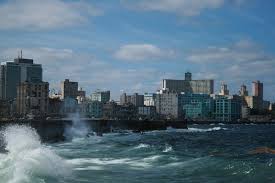
EL MALECÓN HABANERO es un largo muro de concreto desnudo, que custodia una ancha avenida y es asediado por los embates de la corriente del Golfo. El Malecón, cuya construcción comenzó en 1901 y se dilató por unas tres décadas, corre a lo largo del litoral norte de la capital cubana. Ahora se extiende desde el Castillo de La Punta, en la entrada de la bahía, hasta La Chorrera, en la desembocadura del río Almendares, uno de los más bellos de La Habana.
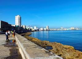
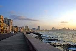
La Avenida marítima más famosa de Cuba; con sus seis vías de carriles es rematada por una ancha acera, coronada por un muro que sirve de asiento a millares de personas que contemplan el mar azul, el paso de los buques, o el rostro amado de quien comparte un lindo momento al apreciar el ocaso.
El nombre del Malecón fue: Avenida del Golfo. La Historia del Malecón comenzó en 1819 cuando se puso en práctica el llamado “ensanche de extramuros”, pues la ciudad estaba creciendo y el espacio costero que iba desde la entrada de la Bahía de La Habana hasta el Torreón de San Lázaro, era solo un espacio abierto de roca y mar, hermoso pero sin otra señal que lo inhóspito del lugar, a donde iban algunas familias a tomar baños de mar.
Desde la zona del litoral habanero donde hoy está el Parque Maceo y hasta el Río Almendares lo que existía entonces era una costa de agudos arrecifes y un monte firme e impenetrable, que las autoridades españolas consideraron siempre como una muralla natural ante ataques y lo llamaban “Monte Vedado”.
Así estuvo muchísimos años, pero en 1859 por toda la calle San Lázaro comenzó a circular el ferrocarril urbano que iba desde las cercanías del puerto hasta la propia desembocadura del Almendares. En esa época aparecieron los barrios El Carmelo y Vedado.
HISTORIA DEL PROYECTO ORIGINAL
Se pensó entonces en el inhóspito litoral habanero y encargaron el proyecto a don Francisco de Albear, el más grande ingeniero cubano de la época. Albear concibió una formulación compleja y acertada de lo que debía ser la obra, más allá de un simple paseo.
Según consta en documentos históricos, la ancha avenida debía construirse a cuatro metros sobre el nivel del mar, separado de la orilla, y en la parte inferior una larga sucesión de 250 bóvedas, para dar cauce a otras necesidades de la ciudad, porque la galería resultante podía servir como línea de ferrocarril y almacén, pensando en el activo puerto habanero, o como línea defensiva militar.
Todo el proyecto costaría 850 mil pesos de la época, pero el gobierno español no se animó a soltar prenda a la administración municipal habanera y la propuesta de Albear durmió un largo sueño.
El primer tramo de esta magnífica obra se comenzó el 6 de mayo de 1901, por los ingenieros Mr. Mead y su ayudante Mr. Whitney bajo el Gobierno Interventor Norteamericano del General Wood, y comprendía desde el Castillo de la Punta hasta los baños de los Campos Elíseos. El 20 de mayo de 1902, al cesar la Intervención, se había llegado hasta la esquina de la calle Crespo, o sea, se habían construido unos 500 metros.
Frente al Castillo de la Punta, en la esquina del Malecón y el Paseo del Prado, se construyó también por los norteamericanos una glorieta para la Banda Municipal —que amenizaba con música las retretas—, la que en 1926 tuvo que demolerse por obstaculizar el tránsito al continuarse el Malecón hacia el puerto. Esta glorieta tuvo importancia desde el punto de vista constructivo, debido a que fue la primera obra realizada de hormigón armado (con cabillas) en Cuba.
En esa esquina se construyó, a principios de siglo, un hotel exclusivo llamado Miramar, donde por primera vez los camareros vistieron de smoking, chaleco con botonadura dorada y sin bigotes. Fue proyectado por el arquitecto “Pepe” Toraya, y según el arquitecto e historiador Luis Bay Sevilla, estuvo de moda en los primeros quince años de la República.
Los cimientos del muro presentaron muchas dificultades en el primer tramo por lo irregular de los arrecifes y en ellos se utilizó hormigón 3:3:6 y en el muro 1:21/2:5. El proyecto norteamericano contemplaba arbolado y grandes candelabros sobre el muro, los que se eliminaron al llegar la temporada invernal y arribar el primer frente frio.
La construcción del Malecón se continuó por los distintos gobiernos y en 1909 llegó hasta la calle Belascoaín, donde se construyó el bar Vista Alegre, que ocupaba la cuña comprendida en esa calle, entre San Lázaro y el Malecón. También en ese tramo se hicieron algunas construcciones importantes, como el Unión Club y el Club de Automovilistas.
En 1916 se llevó hasta el torreón de San Lázaro, para lo que se tuvo que rellenar la caleta del mismo nombre que tenía 93 metros de ancho en su boca y 5.5 metros de profundidad, (frente al actual Hospital Ameijeiras) que había permitido en otra época el desembarco de piratas. Al azotar a la Habana un ciclón en septiembre del año 1919, el mar levantó en peso ese tramo y arrojó enormes trozos de hormigón tierra adentro a bastante distancia que ocasionaron daños e inundaciones nunca vistas ni recordadas por lo que la población y no pocos ingenieros achacaran los destrozos a la construcción del Malecón.
Desde 1914 se habían realizado estudios para prolongar el Malecón hasta la desembocadura del Río Almendares, pero el tramo desde la calle 23 al pasar frente al promontorio de la Batería de Santa Clara (Hotel Nacional) hasta la calle O requería separar el muro unos 30 metros del litoral y rellenar una gran área de 104,500 m² con vistas a construir el monumento al Maine. Este tramo, con el relleno, el parque y el monumento, lo construyó el gobierno de Alfredo Zayas en 1923.
En 1921 se hizo el muro desde el Torreón hasta la calle 23, sin embargo, por la polémica desatada sobre el tramo frente a la Caleta, éste no se reconstruyó hasta el año 1923.
Desde allí interceptaban la continuación del Malecón hacia el oeste la Batería No. 3 a la altura de las calles K y L, donde en el siglo XX se construyó el edificio de la Embajada de los Estados Unidos.
Los estudios para construir el Malecón desde el Castillo de la Punta y el Hotel Miramar hacia el sur, hasta la Pila de Neptuno que se encontraba frente a la Capitanía del Puerto, datan de 1921. Esta avenida se uniría con el tramo del Malecón ya construido dándole un fácil acceso al puerto desde el Vedado. El proyecto comprendía ganarle 111 mil m² al mar, de los cuales gran parte se destinaron a parques y soluciones viales. Las obras del muro, sin el relleno, las ganó en subasta la firma de contratistas Arellano y Mendoza a un costo de 2 millones 101 mil pesos y se calcula que el relleno costó otro millón de pesos adicionales.
Para realizar la obra se colocaron a lo largo de la línea donde se construiría el muro dos hileras de tablestacas de hormigón armado, también se hincaron pilotes en profusión cada 2.50 metros. Sobre las tablestacas y los pilotes, se corrieron arquitrabes de hormigón armado.

CONSTRUCCIÓN POR ETAPAS DEL MALECÓN HABANERO
El muro se realizó a base de unos grandes bloques huecos de hormigón armado, prefabricados en una planta que hicieron al efecto los contratistas en la Ensenada de Guasabacoa.
Estos bloques, aunque de dimensiones variables, como promedio tenían 5 x 4 metros de área y 2 metros de altura y descansaban sobre un fondo preparado con una base de hormigón de 1:11/2:3 y después se rellenaban con hormigón 1:3:21/2, dejando fuera cabillas que se empataban con todo el muro fundido a lo largo de la línea los bloques. En este tramo se gastaron 17 mil toneladas de cemento Portland, 22 mil m³ de arena, 45 mil m³ de piedra picada, 35 mil m³ de rajón, 4 mil 200 toneladas de barras de acero, 295 toneladas de vigas de acero y un millón de pies de madera. La obra se comenzó en marzo de 1926 y se terminó en 1929.
La prolongación del Malecón hacia el oeste, sería obra del gobierno del general Machado y su ministro de Obras Públicas, Carlos Miguel de Céspedes, quien en 1930 lo adelantó hasta la calle G y no fue hasta alrededor del año 1955 en que Batista lo continuó hasta la calle Paseo, donde se interpuso el Palacio de los Deportes, que estaba situado donde hoy está la Fuente de la Juventud frente al Hotel Habana Riviera.
Desde el año 1950 se hablaba de prolongar el Malecón hasta en nivel de la calle 12 del Vedado para a través de un gigantesco puente colgante enlazar con la avenida Primera del Reparto Miramar, hasta cerca de donde posteriormente se construyó el Hotel Rosita de Hornedo, después Sierra Maestra.
Pero la construcción del túnel de Calzada bajo el río Almendares en 1958, determinó que se continuara el Malecón hasta enlazar con esa vía subterránea y después con la Quinta Avenida, lo que se realizó en 1959.
A los 70 años de inaugurado este tramo, en 1999, mientras se realizaban algunos trabajos de reparación en el Castillo de la Punta, se observó que cedía el piso con facilidad, por lo que se mandaron buzos con cámaras fotográficas, que descubrieron que una gran parte del Malecón, en el tramo aledaño al Castillo, había sido socavado por el mar, destruyendo totalmente los bloques de hormigón y con un peligro inmediato de derrumbe, ya que había partes de la acera y muro totalmente en voladizo. La reparación, realizada de inmediato, requirió la inyección de miles de m³ de hormigón hidráulico.
Todas y cada una de estas prolongaciones llevaban implícito cambios en los fabulosos proyectos, los cuales finalmente terminaban en ese muro pelado, largo y amado de los que vivimos en esta ciudad, y que un chistoso definió una vez como “el banco más largo del mundo”.
Desde allí, a las 21.00 de la noche se puede ver la Ceremonia del Cañonazo, famosa en el lugar por ser la señal que se usaba y que, actualmente, se sigue utilizando para avisar del alzamiento de las cadenas que protegen el puerto.

![]()
THE MALECON OF HAVANA, LONG CONCRETE WALL AND MOST FAMOUS MARITIME AVENUE IN CUBA. PHOTOS
Havana’s Malecón is a long wall of bare concrete, which guards a wide avenue and is besieged by the onslaught of the Gulf Stream. The Malecón, whose construction began in 1901 and lasted for about three decades, runs along the northern coast of the Cuban capital. It now extends from the Castillo de La Punta, at the entrance to the bay, to La Chorrera, at the mouth of the Almendares River, one of the most beautiful in Havana.
The most famous maritime avenue in Cuba; With its six lanes, it is topped by a wide sidewalk, crowned by a wall that serves as a seat for thousands of people who contemplate the blue sea, the passing of ships, or the beloved face of those who share a beautiful moment when appreciating the sunset.
The name of the Malecón was: Avenida del Golfo. The History of the Malecón began in 1819 when the so-called “extramural expansion” was put into practice, since the city was growing and the coastal space that went from the entrance of the Bay of Havana to the Torreón de San Lázaro, was only a open space of rock and sea, beautiful but with no other sign than the inhospitability of the place, where some families went to take sea baths.
From the area of the Havana coast where Maceo Park is today and up to the Almendares River, what existed then was a coast of sharp reefs and a firm and impenetrable mountain, which the Spanish authorities always considered as a natural wall against attacks and called it “ “Mount Vedado”.
It remained this way for many years, but in 1859 the urban railway began to circulate along San Lázaro Street, running from the vicinity of the port to the mouth of the Almendares itself. At that time, the El Carmelo and Vedado neighborhoods appeared.
HISTORY OF THE ORIGINAL PROJECT
They then thought of the inhospitable Havana coastline and commissioned the project to Don Francisco de Albear, the greatest Cuban engineer of the time. Albear conceived a complex and accurate formulation of what the work should be, beyond a simple walk.
According to historical documents, the wide avenue had to be built four meters above sea level, separated from the shore, and at the bottom a long succession of 250 vaults, to accommodate other needs of the city, because the gallery The resulting line could serve as a railway line and warehouse, thinking about the active Havana port, or as a military defensive line.
The entire project would cost 850 thousand pesos at the time, but the Spanish government did not dare to release a pledge to the Havana municipal administration and Albear’s proposal slept a long sleep.
The first section of this magnificent work was begun on May 6, 1901, by the engineers Mr. Mead and his assistant Mr. Whitney under the North American Intervenor Government of General Wood, and included from the Castillo de la Punta to the bathrooms of the Elysian Fields. On May 20, 1902, when the Intervention ceased, they had reached the corner of Crespo Street, that is, about 500 meters had been built.
In front of the Castillo de la Punta, on the corner of the Malecón and the Paseo del Prado, a gazebo was also built by the Americans for the Municipal Band – which enlivened the toilets with music – which in 1926 had to be demolished because it hindered traffic. as the Malecón continues towards the port. This roundabout was important from a construction point of view, because it was the first work made of reinforced concrete (with rods) in Cuba.
On that corner, at the beginning of the century, an exclusive hotel called Miramar was built, where for the first time the waiters dressed in tuxedos, vests with gold buttons and without mustaches. It was designed by the architect “Pepe” Toraya, and according to the architect and historian Luis Bay Sevilla, it was fashionable in the first fifteen years of the Republic.
The foundations of the wall presented many difficulties in the first section due to the irregularity of the reefs and 3:3:6 concrete was used in them and 1:21/2:5 in the wall. The North American project included trees and large chandeliers on the wall, which were eliminated when the winter season arrived and the first cold front arrived.
The construction of the Malecón was continued by the different governments and in 1909 it reached Belascoaín Street, where the Vista Alegre bar was built, which occupied the wedge included in that street, between San Lázaro and the Malecón. Also in that section, some important constructions were made, such as the Unión Club and the Automobile Club.
In 1916 it was taken to the tower of San Lázaro, for which the cove of the same name had to be filled in, which was 93 meters wide at its mouth and 5.5 meters deep, (in front of the current Ameijeiras Hospital) that had allowed in another time of the pirate landing. When a cyclone hit Havana in September 1919, the sea lifted the weight of that section and threw enormous pieces of concrete inland for quite a distance, causing damage and flooding never seen or remembered, for which the population and quite a few engineers blamed it. the destruction to the construction of the Malecón.
Since 1914, studies had been carried out to extend the Malecón to the mouth of the Almendares River, but the section from 23rd Street passing in front of the promontory of the Santa Clara Battery (Hotel Nacional) to O Street required separating the wall by about 30 meters. of the coastline and fill in a large area of 104,500 m² with a view to building the Maine monument. This section, with the fill, the park and the monument, was built by the government of Alfredo Zayas in 1923.
In 1921 the wall was built from the Torreón to 23rd Street, however, due to the controversy unleashed over the section in front of La Caleta, it was not rebuilt until 1923.
From there, the continuation of the Malecón to the west was intercepted by Battery No. 3 at K and L streets, where the United States Embassy building was built in the 20th century.
The studies to build the Malecón from the Castillo de la Punta and the Miramar Hotel towards the south, to the Pila de Neptuno that was in front of the Port Captaincy, date back to 1921. This avenue would join the section of the Malecón already built giving you easy access to the port from Vedado. The project included reclaiming 111 thousand m² from the sea, a large part of which was allocated to parks and road solutions. The wall works, without the filling, were won at auction by the contracting firm Arellano y Mendoza at a cost of 2 million 101 thousand pesos and it is estimated that the filling cost another million additional pesos.
To carry out the work, two rows of reinforced concrete sheet piles were placed along the line where the wall would be built, and piles were also driven profusely every 2.50 meters. Reinforced concrete architraves were run over the sheet piles and piles.
CONSTRUCTION BY STAGES OF THE MALECON HABANERO
The wall was made from large hollow reinforced concrete blocks, prefabricated in a plant made for this purpose by contractors in Ensenada de Guanabacoa.
These blocks, although of variable dimensions, were on average 5 x 4 meters in area and 2 meters high and rested on a bottom prepared with a 1:11/2:3 concrete base and were then filled with 1:3 concrete. :21/2, leaving out rods that were tied with the entire cast wall along the line of the blocks. In this section, 17 thousand tons of Portland cement, 22 thousand m³ of sand, 45 thousand m³ of crushed stone, 35 thousand m³ of rajon, 4 thousand 200 tons of steel bars, 295 tons of steel beams and one million wooden feet. The work began in March 1926 and was completed in 1929.

The extension of the Malecón to the west would be the work of the government of General Machado and his Minister of Public Works, Carlos Miguel de Céspedes, who in 1930 advanced it to G Street and it was not until around 1955 that Batista continued it until Paseo Street, where the Sports Palace was located, which was located where the Fountain of Youth is today in front of the Habana Riviera Hotel.
Since 1950 there was talk of extending the Malecón to the level of 12th Street in Vedado to connect with First Avenue of Reparto Miramar through a gigantic suspension bridge, to near where the Hotel Rosita de Hornedo was later built, later Sierra Maestra.
But the construction of the Calzada tunnel under the Almendares River in 1958 determined that the Malecón be continued until it connected with that underground road and then with Fifth Avenue, which was done in 1959.
70 years after this section was inaugurated, in 1999, while some repair work was being carried out at the Castillo de la Punta, it was observed that the floor gave way easily, so divers with cameras were sent, who discovered that a large Part of the Malecón, in the section adjacent to the Castle, had been undermined by the sea, completely destroying the concrete blocks and with an immediate danger of collapse, since there were parts of the sidewalk and wall completely cantilevered. The repair, carried out immediately, required the injection of thousands of m³ of hydraulic concrete.
Each and every one of these extensions implied changes in the fabulous projects, which finally ended in that bare, long and beloved wall of those of us who live in this city, and which a comedian once defined as “the longest bench in the world.” ”.
From there, at 9:00 p.m. you can see the Cannon Shot Ceremony, famous in the place for being the signal that was used and is still used today to warn of the raising of the chains that protect the port.
Agencies/ Wiki/ ElMaleconHabanaHist./ Ecured/ Extractos/Excerpts/ Internet Photos/ Arnoldo Varona/ www.TheCubanHistory.com
THE CUBAN HISTORY, HOLLYWOOD.
![]()
